
Dosiero:Hammurabi Babilonia CA.svg

Grando de tiu PNG antaŭprezento de tiu SVGa dosiero: 644 × 600 rastrumeroj. Aliaj distingivoj: 258 × 240 rastrumeroj | 515 × 480 rastrumeroj | 824 × 768 rastrumeroj | 1 099 × 1 024 rastrumeroj | 2 198 × 2 048 rastrumeroj | 717 × 668 rastrumeroj.
Bildo en pli alta difino (SVG-dosiero, 717 × 668 rastrumeroj, grandeco de dosiero: 169 KB)
| Jen dosiero de la Wikimedia-Komunejo. La priskribo en ties priskriba paĝo estas montrata suben.
|
Resumo
| Priskribo |
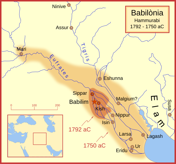
Català: Aquest mapa utilitza els noms que es troben a la Viquipèdia en català per a les ciutats de la Babilònia d'Hammurabi. Mostra el territori babilònic després de la seva ascensió el 1792 aC i després de la seva mort el 1750 aC. Els cursos fluvials i la línia de costa són els d'aquell període de temps; en general, no són els rius o les costes modernes. Es tracta d'una projecció de Mercator, amb el nord en la seva posició habitual.
Hi ha debat fins a quin punt les ciutats de Nínive (Ninive), Tuttul i Assur estaven sota l'autoritat babilònica. Mentre que en la seva introducció al seu codi de lleis, Hammurabi reclama el senyoriu sobre aquestes ciutats, Roaf no n'inclou cap en el seu mapa, en el qual es basa aquest mapa, i Chevalas afirma que "Assur i Nínive es van mantenir durant molt pocs anys." (pàg. 155). Per tant, "no" s'ha inclòs com sota el control d'Hammurabi el 1750 aC.
English: This map uses the names found in the Catalan Wikipedia for the cities of Hammurabi's Babylonia. It shows the Babylonian territory upon his ascension in 1792 BC and upon his death in 1750 BC. The river courses and coastline are those of that time period -- in general, they are not the modern rivers or coastlines. This is a Mercator projection, with north in its usual position.
There is some question to what degree the cities of Nineveh (Ninive), Tuttul, and Assur were under Babylonian authority. While in his introduction to his code of laws, Hammurabi claims lordship over these cities, Roaf does not include any of these in his map, upon which this map is based, and Chevalas states that "Assur and Nineveh were held for a very few years" (p. 155). Therefore, I have not included them as under Hammurabi's control in 1750 BC. |
| Dato | |
| Fonto | Propra verko |
| Aŭtoro | MapMaster |
| Ceteraj versioj |
[]
|


Other versions
References
- Bjorklund, Oddvar; Holmboe, Haakon; Rohr, Anders (1970) Historical Atlas of the World, Barnes & Noble, NY, SBN: 389-00253-4.
- Chavalas, Mark W.; K. Lawson Younger (2003) Mesopotamia and the Bible, Continuum International Publishing Group, ISBN 978-0567082312.
- Hammond World Atlas Corporation (2007) Historical World Atlas, ISBN 9-780843-71391-6
- Roaf, M. (1990) Cultural Atlas of Mesopotamia and the ancient Near East, Oxford: Facts on File. (In general, the basis for the ancient river courses and ancient coastline).
- Van De Mieroop, Marc (2005). King Hammurabi of Babylon: A Biography. Blackwell Publishing. ISBN 1405126604
Permesiloj:
Mi, la posedanto de la aŭtorrajto por ĉi tiu verko, ĉi-maniere publikigas ĝin laŭ la jenaj permesiloj:

|
Estas permesite kopii, disdoni kaj/aŭ redakti ĉi tiun dokumenton, sen senŝanĝaj sekcioj, sen antaŭkovrilaj kaj sen dorskovrilaj tekstoj, laŭ la kondiĉoj de la Permesilo GNU por Liberaj Dokumentoj, Versio 1.2 aŭ ajna pli nova versio eldonita de la Free Software Foundation; sen Senŝanĝaj Sekcioj, Antaŭovrilaj Tekstoj aŭ Malantaŭkovrilaj Tekstoj. Kopio de la permesilo estas inkluzivita en la sekcio titolita GNU Free Documentation License. |
This file is licensed under the Creative Commons Attribution-Share Alike Attribution-Share Alike 4.0 International, 3.0 Unported, 2.5 Generic, 2.0 Generic and 1.0 Generic license.
- Vi rajtas:
- kunhavigi – kopii, distribui kaj publikigi la verkon
- aliigi – modifi, adapti, kompletigi, transformi, uzi la tutan verkon aŭ ties partojn, memstare aŭ en aliaj verkoj
- La verko rajtas esti kunhavigata nur:
- atribuite – Vi devas atribui aŭtorecon, liveri ligilon al la permesilo kaj marki ĉu ŝanĝoj estis faritaj. Faru tion en aprobinda maniero, tamen ne sugestante, ke permesinto aprobas vin aŭ vian uzon.
- samkondiĉe – Se vi rekombinas la verkon, transformas ĝin aŭ kreas devenaĵon bazitan sur ĝi, vi rajtas distribui la rezultan verkon nur laŭ la sama aŭ kongrua permesilo kompare kun ĉi tiu.
Vi povas elekti la permesilon preferatan.
Dosierhistorio
Alklaku iun daton kaj horon por vidi kiel la dosiero tiam aspektis.
| Dato/Horo | Bildeto | Grandecoj | Uzanto | Komento | |
|---|---|---|---|---|---|
| nun | 15:52, 23 feb. 2008 | | 717 × 668 (169 KB) | MapMaster | minor edits |
| 07:15, 23 feb. 2008 |  | 717 × 668 (169 KB) | MapMaster | Changes after seeing the image rendered | |
| 07:05, 23 feb. 2008 |  | 717 × 668 (167 KB) | MapMaster | {{Information |Description=This map uses the names found in the Catalan Wikipedia for the cities of Hammurabi's Babylonia. It shows the Babylonian territory upon his ascension in 1792 BC and upon his death in 1750 BC. The river courses and coastline are |
Dosiera uzado
La jena paĝo ligas al ĉi tiu dosiero:
Suma uzado de la dosiero
La jenaj aliaj vikioj utiligas ĉi tiun dosieron:
- Uzado en ca.wikipedia.org
- Uzado en es.wikipedia.org
- Uzado en gl.wikipedia.org
- Uzado en no.wikipedia.org
- Uzado en oc.wikipedia.org
- Uzado en www.wikidata.org